REVIEW · MEXICO CITY
Hiking adventure in CDMX
Book on Viator →Operated by CDMXEXPERIENCE.COM.MX · Bookable on Viator
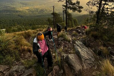
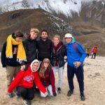
High-altitude effort just 30 minutes from CDMX. This trail climbs from Los Dinamos up to the cult site of Tláloc (about 3,500 meters / 11,275 feet), with tunnels, caves, and a big dose of climbing energy instead of a slow stroll. You get plenty of time for photos too, especially around the top where the wooded ravine opens up.
What I like most is how physical it feels without being chaotic. You get safety gear (a harness and helmet), and the route includes a notable 30-meter (98-foot) staircase, so you know the day won’t be purely “hike and hope.” Second, I love that the plan is built for people who want to start walking regularly or train for bigger climbs in Mexico.
One thing to think about before you book: this is not gentle. Expect 45-degree climbs plus altitude, and people with injuries aren’t allowed—so if you’re nursing anything, this might be the wrong kind of challenge.
In This Review
- Key highlights you’ll feel on the trail
- Los Dinamos to Tláloc: what this hike is really like
- The 8:00 am start in Condesa (and why it matters)
- The climb: 10 km, 45-degree sections, and altitude you’ll notice
- Tunnels, caves, and the 30-meter staircase with harness + helmet
- Views at the top: Tláloc and the wooded ravine payoff
- Snacks, water, and the missing lunch piece
- Language and group style: English private tour
- Communication in the rural zone: don’t rely on cell service
- Who should book this hike (and who should skip)
- Price and value: what you’re paying for without a lunch bundle
- Should you book? My straight answer
- FAQ
- Where do we meet and when does the hike start?
- How long is the hike?
- What route and height should I expect?
- What’s included and what gear will I get?
- Is lunch included?
- What if I have an injury or the weather is bad?
Key highlights you’ll feel on the trail
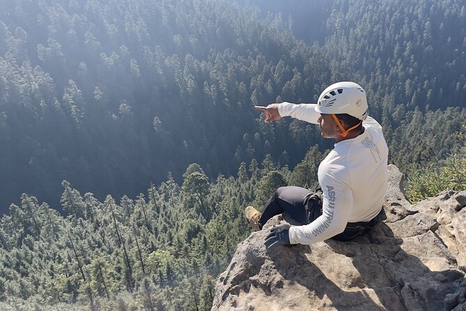
- Tláloc at 3,500 meters: altitude plus cult-site views over the wooded ravine
- 45-degree climbs and a 10 km route: solid workout, not a casual walk
- Tunnels and caves: the terrain changes fast, so you stay alert
- 30-meter staircase with gear: harness and helmet aren’t for show
- No long transfer time: the start is only about 30 minutes from downtown
- Snack breaks included: bottled water and fruit/cookies help you keep going
Los Dinamos to Tláloc: what this hike is really like
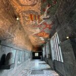
This hike is built around one big idea: you’ll be busy. Not bored. Not “let’s see how it goes.” From the moment you set out from Los Dinamos, the trail leans into effort and variety—climbing sections, plus darker, tighter passages like tunnels and caves. That’s a big part of the appeal. Your brain stays engaged because the route keeps shifting your attention.
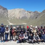
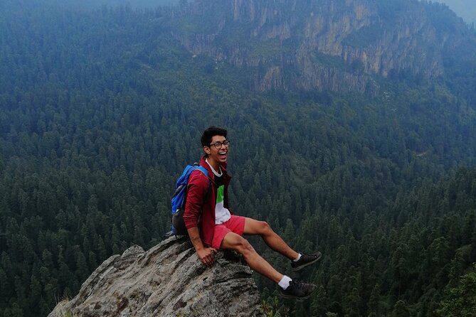
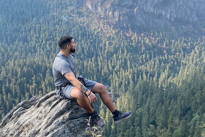
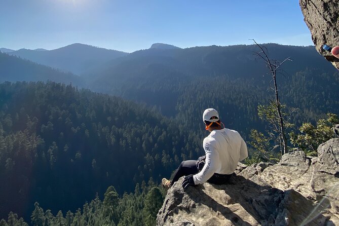
The destination is the cult site of Tláloc at roughly 3,500 meters (11,275 feet). Even if you’re not a history buff, that altitude number matters. Mexico City sits high already, but this is a step up. You’ll likely feel your breathing change, especially during the steeper parts.
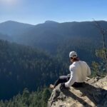
And yes, the views are a major payoff. You’re heading toward impressive outlooks over a wooded ravine, in a place described as a real paradise of rivers and cliffs. I like that the scenery isn’t just at one distant point. You tend to notice it in segments as the terrain opens.
The overall timing is about 6 hours. That’s long enough to feel like a real adventure day, but short enough that you shouldn’t spend your whole afternoon recovering.
You can also read our reviews of more hiking tours in Mexico City
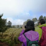
The 8:00 am start in Condesa (and why it matters)
Your morning begins at Casa Bruna Condesa on Alfonso Reyes 216 in the Hipódromo area (Cuauhtémoc), with the start time listed as 8:00 am. That matters more than you’d think. A morning start gives you better weather odds, and it also keeps the day from stretching into a grumpy slog.
The other practical point: the hike is described as only about 30 minutes from downtown CDMX and the operator says they don’t waste time on long, heavy transfers. Translation: you’re spending your energy on the trail, not sitting in a van for hours.
This is a private tour, meaning only your group participates. That usually helps with pacing. On a hike like this—where steep angles and altitude can affect people differently—having a smaller, private group generally makes it easier to keep you safe and moving at a pace that makes sense for your body.
The climb: 10 km, 45-degree sections, and altitude you’ll notice
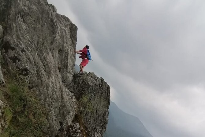
The route is listed at about 10 km (6.2 miles) and includes 45-degree climbs. A 45-degree grade sounds extreme on paper, and it can feel extreme in practice too—especially if you’re already feeling the altitude.
Here’s how I’d interpret this for you: you’re not just hiking uphill. You’re working against gravity. That means shorter steps and steady breathing. If you try to “power walk” with long strides on a steep grade, you’ll spike your effort fast. The route description reads like it’s designed for people who want to start walking regularly or train for climbing at higher elevations later in Mexico.
What about altitude? The top is about 3,500 meters. Even if you’re accustomed to CDMX, you might feel it during the steeper segments. If you’re the type who gets lightheaded with exertion, don’t treat this as a casual day trip. Choose a slower effort early, and keep your pace controlled.
Also, the operator specifically lists a moderate physical fitness level requirement and says people with injuries are not allowed. So if you have anything like a knee issue, ankle instability, or an ongoing back problem, take that seriously. This hike’s steep sections and fixed terrain are not the kind of place where you want to “test your limits.”
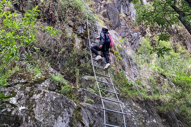
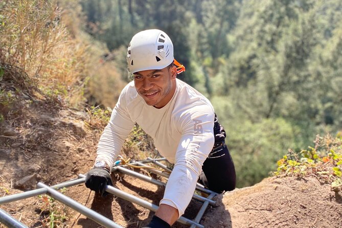
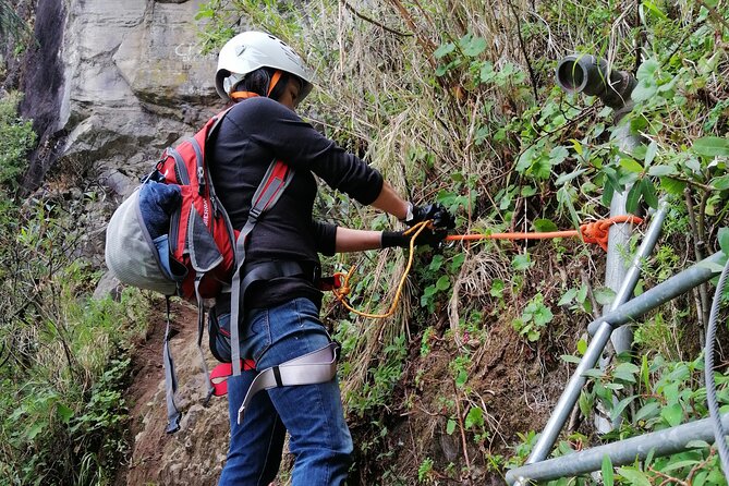
Tunnels, caves, and the 30-meter staircase with harness + helmet
This is one of the reasons the day feels like more than a normal hike.
You’ll cross tunnels and caves along the way. That changes the feel of the trail instantly. It can also change your footing and balance—so you’ll want to stay focused and not rush. Even if you love hiking, treat these sections like they deserve full attention.
Then there’s the big moment: a 30-meter (98-foot) staircase where you’re given the necessary equipment. The included harness and helmet are a clear signal that parts of the route involve safety-rated terrain, not just steps you’d find on a park trail.
I like that the day doesn’t pretend this is risk-free by omitting safety gear. The gear is listed right in the included items, and it’s specifically mentioned around the staircase section. That’s the kind of detail that tells me the operator has thought about the physical reality of the route.
One practical note: tunnels and caves plus a harness/helmet can make it easy to misplace your focus—like you’re thinking about the next photo instead of your footing. On a route like this, that’s how you get sloppy. Plan to move steadily, look up when it’s safe, and let the views come to you rather than hunting them mid-step.
Views at the top: Tláloc and the wooded ravine payoff
Reaching Tláloc is the point where the effort turns into that big “okay, worth it” feeling. You’re climbing toward a cult site sitting at high altitude, and the route promises impressive views of a wooded ravine—described as a paradise of rivers and cliffs.
If you’re into photography, this is where I’d expect you’ll spend the most time. Even without knowing exact timing on stops, the combination of altitude and ravine views usually means stronger light and clearer sightlines near the top.
If you’re going for the full experience (not just the badge), think about how you’ll pace the last stretch. Save enough energy to stand still at the top and actually take it in. People often sprint the final climb, then spend their “view time” gasping and wanting to sit. A steady climb gets you more enjoyment when you finally arrive.


Snacks, water, and the missing lunch piece
The included items are simple and useful:
- Bottled water
- Snacks: fruit and/or cookies
- Harness and helmet
That’s a good setup for a 6-hour outing. You get enough fuel to keep moving without needing to carry everything yourself.
The one missing piece: lunch isn’t included. The description says lunch happens after descending the mountain at the end of the experience. So you should plan for a meal after the hike—either by having money set aside or by planning where you’ll eat once you’re back around the meeting point.
For value, I look at this like a tradeoff: you’re paying for the climb experience, the gear, and the snack support. The operator isn’t selling you a full meal package, and that’s okay as long as you’re ready for it. If you arrive hungry expecting lunch to be solved, you’ll end the day a little annoyed. Arrive with a snack-sized mindset and it feels fair.
Language and group style: English private tour
This experience is offered in English and is private, so you won’t be squeezed into a large mixed crowd. That matters on a technical-feeling hike with caves and a harness/helmet section. Clear communication helps you understand what’s expected on the staircase and other “pay attention” parts.
You’ll also want to treat this as a tour day, not just a self-guided hike. You’ll be depending on the guide’s direction to handle timing and route movement efficiently.
Communication in the rural zone: don’t rely on cell service
One caution shows up in the operator’s own explanation of past logistics issues: the rural area can have no electricity or cell signal, and coordination may run through WhatsApp and the official CDMXExperience platform.
Even if your trip is well-organized, this is the kind of detail that can save you stress. Before the hike, make sure:
- WhatsApp is set up
- You can access the platform where your booking lives
- You keep the provider’s official contact channels handy
This isn’t about expecting problems. It’s about not getting stuck if your phone suddenly can’t do its usual job.
Who should book this hike (and who should skip)
This is a strong match if you want a real workout with real terrain. It’s described as good for people who want to start walking or train for climbing higher mountains in Mexico. The 10 km distance, steep angles, and staircase section make it feel like a training hike, not a casual scenic route.
It’s also a good fit if you:
- Like a route with tunnels/caves and changing terrain
- Enjoy photos from viewpoint moments
- Prefer a private group style
Skip this (or at least reconsider) if you:
- Have any injury that affects walking, knees, ankles, or breathing during exertion (the operator says injuries aren’t allowed)
- Want an easy, low-effort day
- Get uncomfortable with altitude changes and steep climbs
If you’re unsure about your fitness level, treat the listing’s moderate-fit note as “moderate, but expect effort.” The best plan is to be honest about whether you can handle steep grades for extended time.
Price and value: what you’re paying for without a lunch bundle
No price is provided here, so I can’t crunch a numeric value. But I can still help you judge value based on what’s included.
You’re getting:
- Safety gear (harness + helmet)
- Snack support (bottled water + fruit/cookies)
- A guided route that includes technical-feeling terrain (caves/tunnels and a 30-meter staircase)
- A structure that avoids long transfer time
You’re not getting:
- Lunch (served after descent)
So the value is in the guided, safety-equipped nature of the hike and the included basic sustenance. It’s likely a good deal if you want someone else handling the logistics and safety setup. It’s less ideal if you’re hunting for a minimalist hike where you pack your own gear and never touch anything “technical.” This one asks you to show up ready for movement and attention.
Should you book? My straight answer
Book it if you want a workout day that feels like adventure, not just sightseeing. The mix of 45-degree climbs, tunnels/caves, and the 30-meter staircase with harness and helmet turns the hike into a full-body experience. Add in the high-altitude destination at Tláloc and the ravine views, and you get a trip that feels memorable even if you’ve hiked before.
Don’t book if you want easy walking, if you’re carrying an injury, or if altitude and steep grades make you nervous. This route is designed for steady effort and safety-minded terrain. Also plan for lunch after—you’ll need to handle food once you’re done.
If you’re the kind of traveler who likes their days to count, this one fits. Bring your steady pace, respect the steep parts, and you’ll come away with both the views and the satisfaction of a serious hike.
FAQ
Where do we meet and when does the hike start?
You meet at Casa Bruna Condesa, Alfonso Reyes 216, Hipódromo, Cuauhtémoc, 06100 Ciudad de México, CDMX. The listed start time is 8:00 am.
How long is the hike?
The experience runs about 6 hours (approx.).
What route and height should I expect?
The route is about 10 km (6.2 miles) and includes 45-degree climbs. The hike heads up to Tláloc, at about 3,500 meters above sea level (11,275 feet).
What’s included and what gear will I get?
You get bottled water, snacks (fruit and/or cookies), and safety gear including a harness and helmet.
Is lunch included?
No. Lunch is not included, and it’s served after descending the mountain at the end of the experience.
What if I have an injury or the weather is bad?
The tour requires moderate physical fitness and says people with injuries are not allowed. It also requires good weather; if it’s canceled due to poor weather, you’ll be offered a different date or a full refund.